Overview
|
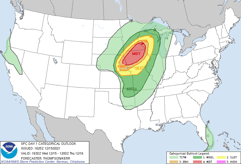
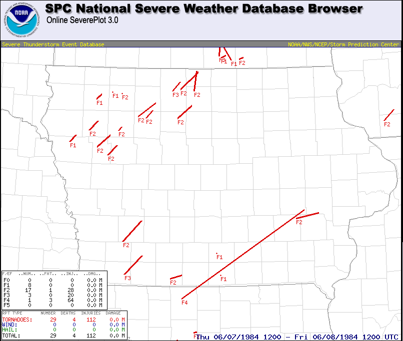
December 15, 2021 was an unprecedented and historic event for the state of Iowa. It featured the first derecho in December anywhere in the United States and the first Moderate Risk (Level 4 or 5) of severe thunderstorms issued by the NWS Storm Prediction Center in December in Iowa. Officially, it set the new record for most tornadoes in Iowa and the most EF-2/F-2 or stronger tornadoes in a single day in Iowa since 1950. Finally, it will break the all-time December record high temperature for Iowa. The main feature was a powerful low pressure that rapidly moved from the Colorado Rockies into Siouxland and eventually over western Lake Superior on December 15, 2021. Gusty, environmental winds preceded a line of severe thunderstorms, which produced numerous tornadoes and thunderstorm wind gusts across the state and region. There were 63 confirmed tornadoes that occurred in Iowa with 21 of those tornadoes being rated EF-2. Sixty three is officially the most tornadoes in Iowa in a single day with the previous being 35 tornadoes on August 31, 2014 (2014 Iowa Tornadoes | Journal Article). Further, 21 EF-2 tornadoes is officially the most EF-2/F-2 or stronger tornadoes in a single day with the previous being 16 tornadoes on June 7, 1984 (Tornado Tracks | NOAA Technical Memo). Prior to this event, a total of 5 tornadoes had occurred in Iowa in December since 1950 with all of them in southeastern Iowa. To have over 10 times that many tornadoes in a single day is unprecedented in any month, let alone the month of December! Numerous straight line wind gusts were also associated with these thunderstorms, some in excess of 80 mph. During the event, nearly the entire state of Iowa was under a Severe Thunderstorm Warning at some point. Audubon reported the highest gust in Iowa at 88 mph. This storm also met the criteria for a “derecho'', which makes it the first derecho on record in the month of December anywhere in the United States. Finally, we had an unofficial gust of 108 mph recorded by a mesonet station near Sheffield, Iowa associated with one of the tornadic circulations. After the line of storms had passed, numerous strong, non-thunderstorm wind gusts over 70 mph occurred overnight. The top three non-thunderstorm wind gusts were 83 mph in Decatur City, 81 mph in Marshalltown, and 80 mph in Johnston. The Des Moines International Airport recorded a 74 mph non-thunderstorm wind gust, which is the highest non-thunderstorm wind gust at this location since 1970. In addition to the severe weather and strong non-thunderstorm winds, the temperatures were remarkable and record setting. Numerous record daily highs were broken by many degrees. In addition and preliminarily, the all-time December record high temperature for Iowa of 74 degrees that was set in Thurman, IA on December 6, 1939 was broken with four sites reaching 75 degrees (Oskaloosa, Muscatine, Iowa City, and Ottumwa).
Overall, this event cost over 1 billion dollars (December 2021 report) in damages across the Midwest.
Sioux Falls, SD | Twin Cities, MN | La Crosse, WI Omaha, NE | Quad Cities, IA/IL | Green Bay, WI Pueblo, CO | Kansas City, MO | Milwaukee, WI Wichita, KS | Topeka, KS | Hastings, NE
ALL DATA REMAINS PRELIMINARY AND SUBECT TO CHANGE. Additional damage reports and analysis of satellite imagery are ongoing to refine current tornado paths and investigate and search for possible additional tornadoes. Last update: February 8, 2022 4:04am CST. |
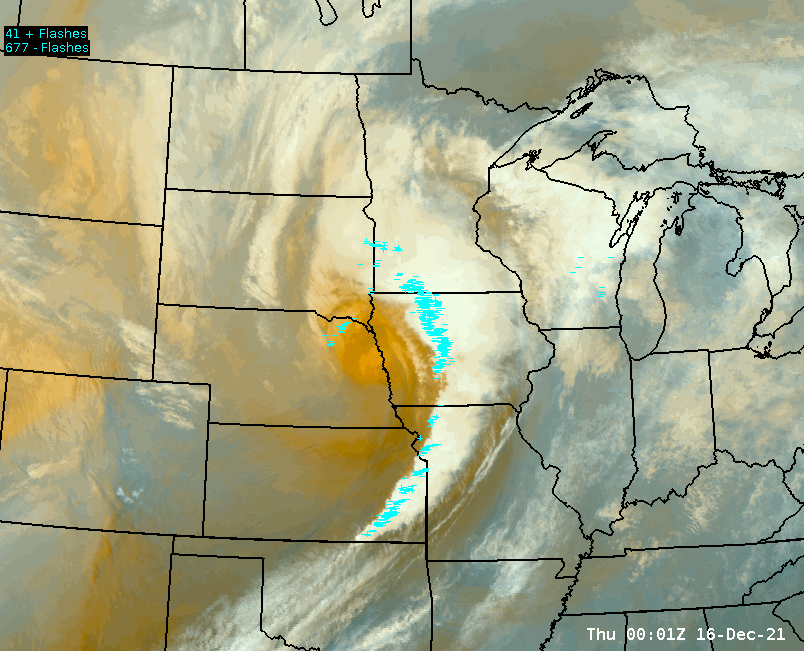
Fast Multi-Radar Multi-Sensor (MRMS) animation of the thunderstorms/derecho moving through Iowa on December 15, 2021. |
 |
 |
 |
| Storm Reports from December 15, 2021 | National Weather Service Severe Thunderstorm and Tornado Warnings issued December 15-16, 2021 | Significant Wind Gusts Reports from the Storm. |
Tornadoes
|
Tornado #1 - SW of Kenwood
|
||||||||||||||||
|
Tornado #2 - Atlantic to Hamlin
|
||||||||||||||
|
||||||||||||||
|
||||||||||||||
|
Tornado #3 - South and East of Exira
|
||||||||||||||
|
|
Tornado #4 - West of Guthrie Center
|
||||||||||||||
|
|
Tornado #5 - West of Breda to Lytton
|
||||||||||||||||
|
|
Tornado #6 - Bayard
|
||||||||||||||
|
||||||||||||||
|
Tornado #7 - Between Carroll and Glidden
|
||||||||||||||
|
|
Tornado #8 - Springbrook to Bagley, Jefferson, and Paton
|
||||||||||||||
|
||||||||||||||
|
Tornado #9 - Bagley to Grand Junction to east of Dana
|
||||||||||||||
|
|
Tornado #10 - SW of Jefferson
|
||||||||||||||
|
|
Tornado #11 - Far W of Jefferson
|
||||||||||||||
|
|
Tornado #12 - South of Churdan
|
||||||||||||||
|
|
Tornado #13 - East of Lake City
|
||||||||||||||||
|
Tornado #14 - Lohrville to Knierim
|
||||||||||||||
|
|
Tornado #15 - East of Grand Junction to Dayton
|
||||||||||||||
|
|
Tornado #16 - South of Somers to Barnum
|
||||||||||||||
|
|
Tornado #17 - Ayrshire to Graettinger
|
||||||||||||||
|
|
Tornado #18 - SW of Paton to NW of Lehigh
|
||||||||||||||||
|
||||||||||||||||
|
Tornado #19 - Southeast of Palmer
|
||||||||||||||||
|
Tornado #20 - Near Pilot Mound to NW of Stanhope Boone, Webster, and Hamilton Counties
|
||||||||||||||
|
|
Tornado #21 - West of Gilmore City
|
||||||||||||||||
|
Tornado #22 - Near Stratford to W of Kamrar
|
||||||||||||||
|
|
Tornado #23 - North of Rutland
|
||||||||||||||||
|
||||||||||||||||
|
Tornado #24 - West of Duncombe
|
||||||||||||||
|
|
Tornado #25 - East to Northeast of Stanhope
|
||||||||||||||||
|
Tornado #26 - West of Webster City
|
||||||||||||||||
|
Tornado #27 - West of Galt
|
||||||||||||||
|
|
Tornado #28 - Rowan to NE of Meservey
|
||||||||||||||
|
|
Tornado #29 - Alden to Bradford
|
||||||||||||||
|
|
Tornado #30 - Iowa Falls to Dumont
|
||||||||||||||
|
|
Tornado #31 - East of Kanawha
|
||||||||||||||||
|
Tornado #32 - Chapin to Sheffield
|
||||||||||||||||
|
||||||||||||||||
|
Tornado #33 - Southeast of Hansell
|
||||||||||||||
|
|
Tornado #34 - East of Rockwell
|
||||||||||||||||
|
Tornado #35 - West of Scarville
|
||||||||||||||
|
|
Tornado #36 - West of Greene
|
||||||||||||||
|
|
Tornado #37 - Northeast of Rock Falls
|
||||||||||||||||
|
Tornado #38 - Kensett to Northwood
|
||||||||||||||
|
|
Tornado #39 - Southeast of Newton
|
||||||||||||||
|
|
Tornado #40 - Northeast of Northwood
|
||||||||||||||||
|
Tornado - LOCATION
Track Map 
Downloadable KMZ File |
||||||||||||||||
|
||||||||||||||||
|
Tornado - LOCATION
Track Map
Downloadable KMZ File |
||||||||||||||||
|
||||||||||||||||
The Enhanced Fujita (EF) Scale classifies tornadoes into the following categories:
| EF0 Weak 65-85 mph |
EF1 Moderate 86-110 mph |
EF2 Significant 111-135 mph |
EF3 Severe 136-165 mph |
EF4 Extreme 166-200 mph |
EF5 Catastrophic 200+ mph |
 |
|||||
Storm Reports
Click map below to go to an interactive webpage or see below for a text summary of storm reports across Iowa.
|
Storm Reports across Iowa December 15, 2021 3pm to December 16, 2021 6am
| Office | Report Time (Local) | County | Location | Event Type | Mag. | Remark |
| DMX | 2021/12/15 15:49 | DECATUR | 2 ENE LAMONI | NON-TSTM WND GST | 60 | |
| DMX | 2021/12/15 15:49 | DECATUR | 2 ENE LAMONI | NON-TSTM WND GST | 60 | ASOS STATION KLWD LAMONI AIRPORT. |
| DMX | 2021/12/15 16:08 | POLK | 1 SSW JOHNSTON | NON-TSTM WND DMG | TREE DOWN ON A POWER LINE RESULTING IN POWER OUTAGE INCLUDING TRAFFIC LIGHTS. | |
| FSD | 2021/12/15 16:17 | WOODBURY | 2 S SALIX | TORNADO | ||
| FSD | 2021/12/15 16:17 | WOODBURY | 2 SW BRONSON | TORNADO | ||
| FSD | 2021/12/15 16:19 | WOODBURY | HORNICK | TSTM WND DMG | OVERTURNED PROPANE TANKS. TIME ESTIMATED FROM RADAR. | |
| FSD | 2021/12/15 16:20 | WOODBURY | 4 W BRONSON | TSTM WND DMG | BUILDING DAMAGED. TIME ESTIMATED FROM RADAR. | |
| OAX | 2021/12/15 16:20 | POTTAWATTAMIE | 1 SW COUNCIL BLUFFS | TSTM WND GST | 62 | MESONET STATION RCBI4 COUNCIL BLUFFS (I-80). |
| FSD | 2021/12/15 16:21 | WOODBURY | 2 E SERGEANT BLUFF | TSTM WND DMG | ROOFS OFF A COUPLE OF HOMES BETWEEN SERGEANT BLUFF AND BRONSON. TIME ESTIMATED FROM RADAR. | |
| FSD | 2021/12/15 16:21 | WOODBURY | 5 WNW SIOUX CITY | TSTM WND DMG | TREE UPROOTED. REPORT VIA SOCIAL MEDIA AND TIME ESTIMATED FROM RADAR. | |
| OAX | 2021/12/15 16:21 | POTTAWATTAMIE | 1 ENE COUNCIL BLUFFS | TSTM WND DMG | NINE LOADED COAL CARS ROLLED OFF TRACKS. | |
| OAX | 2021/12/15 16:22 | FREMONT | 8 WSW SIDNEY | TSTM WND GST | 83 | MESONET STATION NEAR SIDNEY AT I29/HWY 2. |
| OAX | 2021/12/15 16:22 | HARRISON | 2 W MISSOURI VALLEY | TSTM WND GST | 58 | MESONET STATION UP118 2.2 W MISSOURI VALLEY (UPR). |
| OAX | 2021/12/15 16:22 | HARRISON | MISSOURI VALLEY | TSTM WND GST | 83 | |
| OAX | 2021/12/15 16:22 | MILLS | 2 N MALVERN | TSTM WND DMG | POWER LINES ACROSS HIGHWAY 34. | |
| FSD | 2021/12/15 16:23 | WOODBURY | 1 WSW SERGEANT BLUFF | TSTM WND GST | 82 | |
| FSD | 2021/12/15 16:24 | WOODBURY | 4 ENE SERGEANT BLUFF | TSTM WND DMG | DAMAGE TO BUILDING. | |
| OAX | 2021/12/15 16:24 | POTTAWATTAMIE | 4 WSW MCCLELLAND | TORNADO | A NARROW BUT STRONG TORNADO TRACKED ALONG ROAD L34 THROUGH SHERWOOD COUNTRY ESTATES BEFORE ENDING NEAR JUNIPER ROAD. THE MAXIMUM DAMAGE WAS SUSTAINED TO A HOME IN SHERWOOD COUNTRY ESTATES WHERE THE NARROW TORNADO REMOVED THE MAJORITY OF A HOMES ROOF AND DAMAGED OTHER NEARBY HOMES AS WELL. | |
| OAX | 2021/12/15 16:24 | POTTAWATTAMIE | 5 W MCCLELLAND | TSTM WND DMG | FIRE CHIEF REPORTED POWER LINES AND POLES DOWN FOR ABOUT A 1/4 MILE FROM HOMESTEAD AVE TO L-34 ALONG RAILROAD HIGHWAY. | |
| FSD | 2021/12/15 16:25 | WOODBURY | 3 SE SIOUX CITY | TSTM WND DMG | POWER POLES LEARNING. REPORT RECEIVED VIA SOCIAL MEDIA. TIME ESTIMATED FROM RADAR. | |
| OAX | 2021/12/15 16:25 | POTTAWATTAMIE | 3 WNW MCCLELLAND | TSTM WND DMG | MAJOR HOME DAMAGE IN WESTON. | |
| OAX | 2021/12/15 16:27 | POTTAWATTAMIE | 1 NW TREYNOR | TSTM WND DMG | POWERLINES DOWN. | |
| OAX | 2021/12/15 16:29 | POTTAWATTAMIE | 4 E TREYNOR | TSTM WND DMG | LARGE TREE ON HOUSE. | |
| OAX | 2021/12/15 16:29 | POTTAWATTAMIE | 4 W UNDERWOOD | TSTM WND DMG | ROOF BLOWN OFF A HOUSE ON L-34 WEST OF UNDERWOOD. | |
| FSD | 2021/12/15 16:31 | WOODBURY | 2 E LAWTON | TSTM WND DMG | POWER LINES DOWN ACROSS HWY 20. TIME ESTIMATED FROM RADAR. | |
| FSD | 2021/12/15 16:31 | WOODBURY | 2 ENE LAWTON | TSTM WND DMG | POLE SHED ROOF OFF WITH DEBRIS BLOWN INTO FIELD. TIME ESTIMATED FROM RADAR. | |
| OAX | 2021/12/15 16:31 | POTTAWATTAMIE | 2 E UNDERWOOD | TORNADO | A NARROW EF-2 TORNADO BEGAN PRODUCING DAMAGE NEAR MAHOGANY ROAD AND 290TH ST AND TRACKED NORTH NORTHEAST INTO THE SOUTHEAST EDGE OF NEOLA AND THEN CAUSED INTERMITTENT DAMAGE NEAR RAILROAD HIGHWAY NORTH OF NEOLA. THE MOST SIGNIFICANT DAMAGE WAS TO A HOME ALONG 290TH STREET WHERE THE ROOF WAS REMOVED AND WALLS BLOWN OUT. A NEARBY GARAGE WAS MOVED OFF OF ITS FOUNDATION AND APPROXIMATELY 10 MATURE TREES WERE ALL UPROOTED BEHIND THE HOME WITH SUBSTANTIAL DAMAGE TO HARDWOOD TREES IN THE FRONT YARD. THE NARROW NATURE OF THIS TORNADO WAS EVIDENT IN THE DAMAGE PATH AS NEARBY BARNS ON THE EAST SIDE OF THE TRACK HAD LOW-END DAMAGE, POSSIBLY OWING TO THE SIGNIFICANT FORWARD SPEED OF THE TORNADO. THE TORNADO WAS SEEN BRIEFLY BY THE RESIDENT BEFORE SEEKING SHELTER. A BUSINESS ON THE SOUTHEAST SIDE OF NEOLA ALSO HAD SUBSTANTIAL DAMAGE TO LARGE METAL BUILDINGS, AT LEAST TWO OF WHICH WERE DESTROYED. | |
| OAX | 2021/12/15 16:32 | POTTAWATTAMIE | 2 SW NEOLA | TORNADO | FROM VIDEO AND TDS. TORNADO ON THE GROUND FOR AT LEAST 2 MINUTES. DAMAGE REPORTED IN NEOLA. | |
| FSD | 2021/12/15 16:33 | WOODBURY | 3 ENE LAWTON | TORNADO | REPORT OF POWER FLASHES FROM POWER LINES. | |
| FSD | 2021/12/15 16:34 | WOODBURY | 1 W ANTHON | TSTM WND DMG | CATTLE BARN AND GARAGE DAMAGED. TIME ESTIMATED FROM RADAR. | |
| OAX | 2021/12/15 16:34 | HARRISON | 4 NE LOGAN | TSTM WND DMG | DELAYED REPORT, TIME ESTIMATED FROM RADAR. REPORT FROM MPING: TREES UPROOTED OR SNAPPED; ROOF BLOWN OFF. | |
| FSD | 2021/12/15 16:35 | PLYMOUTH | KINGSLEY | TSTM WND DMG | ROOF TOWN OFF OF BUILDING. TIME ESTIMATED FROM RADAR. | |
| OAX | 2021/12/15 16:35 | POTTAWATTAMIE | 5 ENE COUNCIL BLUFFS | NON-TSTM WND GST | 79 | AWOS STATION KCBF COUNCIL BLUFFS AIRPORT. |
| OAX | 2021/12/15 16:36 | POTTAWATTAMIE | 5 ENE COUNCIL BLUFFS | TSTM WND GST | 79 | |
| OAX | 2021/12/15 16:38 | POTTAWATTAMIE | 1 NE UNDERWOOD | TSTM WND DMG | LARGE GARAGE DOORS ON CITY BUILDING BLOWN IN. | |
| OAX | 2021/12/15 16:38 | POTTAWATTAMIE | 2 SE UNDERWOOD | TSTM WND GST | 80 | |
| OAX | 2021/12/15 16:40 | POTTAWATTAMIE | 5 ESE CARSON | TSTM WND DMG | MACHINE SHED DESTROYED. | |
| OAX | 2021/12/15 16:41 | SHELBY | TENNANT | TSTM WND DMG | LARGE TREE FELL ON HOME. | |
| FSD | 2021/12/15 16:43 | IDA | 2 NW BATTLE CREEK | TSTM WND DMG | MACHINE SHED DAMAGED. TIME ESTIMATED FROM RADAR. | |
| OAX | 2021/12/15 16:45 | HARRISON | 7 SSW MODALE | TSTM WND GST | 55 | MESONET STATION DEOI4 DESOTO. |
| FSD | 2021/12/15 16:48 | IDA | 6 NW IDA GROVE | TSTM WND DMG | MACHINE SHED DAMAGE. TIME ESTIMATED FROM RADAR. | |
| FSD | 2021/12/15 16:50 | IDA | 4 SSE HOLSTEIN | TSTM WND DMG | TREES DOWN. TIME ESTIMATED FROM RADAR. | |
| OAX | 2021/12/15 16:50 | POTTAWATTAMIE | 3 ENE AVOCA | TSTM WND GST | 67 | MESONET STATION RAVI4 AVOCA (I-80). |
| FSD | 2021/12/15 16:52 | CHEROKEE | 6 SSW CLEGHORN | TSTM WND DMG | MACHINE SHED DESTROYED AND GRAVITY WAGON TIPPED OVER. REPORT VIA SOCIAL MEDIA. | |
| OAX | 2021/12/15 16:53 | HARRISON | 2 S WOODBINE | TSTM WND DMG | TREES UPROOTED OR SNAPPED; ROOF BLOWN OFF. | |
| OAX | 2021/12/15 16:53 | POTTAWATTAMIE | 1 SE SHELBY | TSTM WND DMG | SEMI ROLLED OVER ON I-80W PER TWITTER PHOTO. | |
| DMX | 2021/12/15 16:55 | CRAWFORD | 4 NNE BUCK GROVE | TSTM WND GST | 81 | AWOS STATION KDNS DENISON AIRPORT. |
| OAX | 2021/12/15 16:55 | SHELBY | 5 S HARLAN | NON-TSTM WND GST | 72 | AWOS STATION KHNR HARLAN AIRPORT. |
| OAX | 2021/12/15 16:55 | SHELBY | HARLAN | TSTM WND GST | 72 | |
| FSD | 2021/12/15 16:56 | CHEROKEE | 1 SSW MARCUS | TSTM WND DMG | ROOFS WERE BLOWN OFF OF A FEW BUILDINGS AND SEMI WAS BLOWN OFF THE ROAD. TIME ESTIMATED FROM RADAR. | |
| FSD | 2021/12/15 16:57 | IDA | 2 NNW GALVA | TSTM WND DMG | HOUSE DAMAGED WITH ROOF TORN OFF. HOOP BARN DESTROYED AND 100 YEAR OLD MARCHINE SHED DESTOYED. TIME ESTIMATED FROM RADAR. | |
| OAX | 2021/12/15 17:00 | MILLS | 2 N MALVERN | TSTM WND DMG | POWER LINES ACROSS HIGHWAY 34. | |
| OAX | 2021/12/15 17:00 | POTTAWATTAMIE | 1 NW TREYNOR | TSTM WND DMG | POWERLINES DOWN. | |
| DMX | 2021/12/15 17:01 | CASS | 3 SSW BRAYTON | TORNADO | STORM CHASER REPORTED FLIPPED SEMIS ON I-80 AND POWER FLASHES ASSOCIATED WITH A TORNADO. | |
| FSD | 2021/12/15 17:01 | BUENA VISTA | 5 SW ALTA | TSTM WND DMG | NUMEROUS TREES AND BRANCHES DOWN. REPORT RECEIVED VIA SOCIAL MEDIA. TIME ESTIMATED FROM RADAR. | |
| DMX | 2021/12/15 17:02 | CASS | 1 NW ATLANTIC | TORNADO | STORM CHASER REPORTED TORNADO ON THE WEST SIDE OF ATLANTIC. | |
| OAX | 2021/12/15 17:02 | POTTAWATTAMIE | 3 W MCCLELLAND | TSTM WND DMG | SEMI ROLLED OVER. I-80W 13 MM NEAR MCCLELLAND, IA. | |
| FSD | 2021/12/15 17:03 | CHEROKEE | AURELIA | TSTM WND DMG | SILO DAMAGED, TREES DOWN AND SHEET METAL FROM BUILDINGS ON ROAD. POWER OUT IN TOWN. TIME ESTIMATED FROM RADAR. | |
| FSD | 2021/12/15 17:03 | CHEROKEE | AURELIA | TSTM WND DMG | UPDATES PREVIOUS TSTM WND DMG REPORT FROM AURELIA. SILO DAMAGED, TREES DOWN AND SHEET METAL FROM BUILDINGS ON ROAD. 3 RAIL CARS BLOWN OVER, AND A HOME DESTROYED. POWER OUT IN TOWN. TIME ESTIMATED FROM RADAR. | |
| DMX | 2021/12/15 17:04 | AUDUBON | EXIRA | TORNADO | CORRECTS PREVIOUS TORNADO REPORT FROM EXIRA. DAMAGE TO MULTIPLE TO BARN BUILDINGS NEAR EXIRA. DELAYED REPORT VIA SOCIAL MEDIA PHOTOS. TIME ESTIMATED VIA RADAR. | |
| FSD | 2021/12/15 17:04 | CHEROKEE | LARRABEE | TSTM WND DMG | DAMAGE TO MACHINE SHEDS AND SOME ROOFS DAMAGE. TIME ESTIMATED FROM RADAR. | |
| DMX | 2021/12/15 17:07 | AUDUBON | 4 SE AUDUBON | TORNADO | DELAYED REPORT. PICTURES CAME IN VIA EMAIL EAST OF HAMLIN, IA. TIME ESTIMATED BASED ON RADAR AND OTHER REPORTS IN AUDUBON COUNTY. | |
| FSD | 2021/12/15 17:10 | BUENA VISTA | 4 WSW LAKESIDE | TSTM WND GST | 51 | TIME ESTIMATED FROM RADAR. |
| FSD | 2021/12/15 17:10 | O'BRIEN | 2 SSE SUTHERLAND | TSTM WND DMG | DESTROYED BUILDING BLOCKING HIGHWAY 10 SOUTH OF SUTHERLAND. TIME ESTIMATED FROM RADAR. | |
| DMX | 2021/12/15 17:11 | AUDUBON | AUDUBON | TSTM WND GST | 88 | PWS RECORDED WIND GUST OF 88 MPH. |
| FSD | 2021/12/15 17:11 | O'BRIEN | SUTHERLAND | TSTM WND DMG | LARGE TREE BRANCH DOWN IN TOWN. TIME ESTIMATED FROM RADAR. | |
| DMX | 2021/12/15 17:12 | ADAIR | ADAIR | TSTM WND GST | 76 | PWS RECORDED A 76 MPH WIND GUST. |
| DMX | 2021/12/15 17:15 | ADAIR | 2 S ADAIR | TSTM WND GST | 80 | EM REPORTS 80+ MPH WINDS, ZERO VISIBILITY SOUTH OF ADAIR. |
| OAX | 2021/12/15 17:15 | PAGE | 1 SSE CLARINDA | TSTM WND GST | 61 | |
| OAX | 2021/12/15 17:15 | PAGE | 2 SSE CLARINDA | NON-TSTM WND GST | 61 | AWOS STATION KICL CLARINDA AIRPORT. |
| DMX | 2021/12/15 17:17 | GUTHRIE | 8 W GUTHRIE CENTER | TSTM WND GST | 65 | EM REPORTS 1/2 INCH HAIL AND ESTIMATED 65 MPH WIND, HWY 44 AND FRONTIER ROAD IN GUTHRIE CO. |
| OAX | 2021/12/15 17:22 | POTTAWATTAMIE | 8 E OAKLAND | TSTM WND DMG | TREE ON ROADWAY. US-6 38 MM. | |
| DMX | 2021/12/15 17:23 | CARROLL | COON RAPIDS | HAIL | 1 | |
| OAX | 2021/12/15 17:24 | POTTAWATTAMIE | 5 E COUNCIL BLUFFS | TSTM WND DMG | TREE ON ROAD IA-92 AT 8 MM & EASTERN HILLS DRIVE. | |
| DMX | 2021/12/15 17:25 | GUTHRIE | 4 NE GUTHRIE CENTER | TSTM WND GST | 73 | |
| FSD | 2021/12/15 17:25 | CLAY | 3 E ROYAL | TSTM WND DMG | LARGE PINE TREE BLOW DOWN. TIME ESTIMATED FROM RADAR. | |
| DMX | 2021/12/15 17:27 | CARROLL | COON RAPIDS | TSTM WND GST | 70 | |
| DMX | 2021/12/15 17:27 | DECATUR | 2 ENE LAMONI | TSTM WND GST | 60 | LAMONI MUNICIPAL AIRPORT RECORDED 52 KT WIND GUST. |
| DMX | 2021/12/15 17:27 | GREENE | 4 S SCRANTON | TSTM WND GST | 73 | PWS RECORDED WIND GUST OF 73 MPH. |
| DMX | 2021/12/15 17:31 | CARROLL | RALSTON | TSTM WND GST | 70 | WIND ESTIMATES OF AT LEAST 70 MPH FROM RALSTON FIRE DEPT. SOME SPORADIC DAMAGE BEGINNING TO OCCUR. |
| FSD | 2021/12/15 17:31 | CLAY | 1 SSE SPENCER | TSTM WND DMG | TREES DOWN IN TOWN. TIME ESTIMATED FROM RADAR. | |
| DMX | 2021/12/15 17:32 | GUTHRIE | YALE | TSTM WND DMG | REPORT OF AN OUTBUILDING DESTROYED. | |
| FSD | 2021/12/15 17:33 | CLAY | 3 WNW SPENCER | TSTM WND GST | 54 | |
| DMX | 2021/12/15 17:34 | GREENE | 2 W JEFFERSON | TORNADO | PUBLIC RELAYED POSSIBLE TORNADO DAMAGE WEST OF JEFFERSON, INCLUDING LARGE PORTION OF GARAGE DAMAGED/MISSING. TIME ESTIMATED FROM RADAR. | |
| OAX | 2021/12/15 17:34 | MILLS | 2 NNW PACIFIC JUNCTION | TSTM WND DMG | SEMI ROLLOVER. I-29N AT 35 MM. | |
| OAX | 2021/12/15 17:34 | POTTAWATTAMIE | NEOLA | TSTM WND DMG | OUT BUILDINGS BLOWN OVER, HOUSES DAMAGED, POWER LINES DOWN, GAS LEAK - TDS NOTED IN THE AREA ON RADAR. | |
| DMX | 2021/12/15 17:35 | CARROLL | 3 S GLIDDEN | TSTM WND DMG | OUTBUILDING DESTROYED AT 240TH ST. AND TIMBER AVE. SIZE OF BUILDING UNKNOWN. | |
| FSD | 2021/12/15 17:35 | DICKINSON | 8 WSW MILFORD | TSTM WND GST | 60 | |
| DMX | 2021/12/15 17:39 | DALLAS | LINDEN | TSTM WND GST | 62 | PWS RECORDED 62 MPH WIND GUSTS. |
| DMX | 2021/12/15 17:39 | GREENE | GRAND JUNCTION | TSTM WND DMG | PUBLIC RELAYED SIDING MISSING ON HOUSE ON SE SIDE OF GRAND JUNCTION. TIME ESTIMATED FROM RADAR. | |
| FSD | 2021/12/15 17:40 | DICKINSON | 4 ENE FOSTORIA | TSTM WND DMG | ROOF GONE OFF OF A LARGE SHED, 2-3 TREES UPROOTED AND SEVERAL POWER POLES WERE KNOCKED DOWN. TIME ESTIMATED FROM RADAR. | |
| DMX | 2021/12/15 17:41 | DALLAS | MINBURN | TSTM WND GST | 70 | 60-70 MPH WIND GUST REPORTS FROM AMATEUR RADIO OPERATORS IN MINBURN. |
| DMX | 2021/12/15 17:41 | DALLAS | PERRY | TSTM WND GST | 70 | 60 TO 70 MPH WIND GUST REPORTS FROM AMATEUR RADIO OPERATORS IN PERRY. |
| DMX | 2021/12/15 17:41 | GREENE | 2 WNW JEFFERSON | TSTM WND DMG | DAMAGE TO POWER POLES ALONG HIGHWAY 30 WEST OF JEFFERSON. REPORT VIA SOCIAL MEDIA. DELAYED REPORT AND TIME/LOCATION ESTIMATED BY RADAR. | |
| DMX | 2021/12/15 17:42 | PALO ALTO | 3 NE AYRSHIRE | TSTM WND DMG | EXTENSIVE BUILDING DAMAGE TO THE NORTHEAST OF AYRSHIR. | |
| DMX | 2021/12/15 17:45 | DALLAS | 3 ESE DAWSON | TSTM WND GST | 74 | DIALED INTO PERRY AWOS. |
| DMX | 2021/12/15 17:45 | DALLAS | 3 SW MINBURN | TSTM WND GST | 75 | 3 SW MINBURN EST 75 MPH. |
| DMX | 2021/12/15 17:45 | GREENE | 4 SW DANA | TORNADO | DAMAGE TO FARMSTEAD BUILDINGS NORTHEAST OF JEFFERSON NEAR INTERSECTION OF 195TH AND R AVE. TIME ESTIMATED BY RADAR. REPORT VIA SOCIAL MEDIA. | |
| DMX | 2021/12/15 17:45 | PALO ALTO | 2 ESE RUTHVEN | TSTM WND DMG | HOG BUILDING COMPLETELY DESTROYED. | |
| DMX | 2021/12/15 17:45 | PALO ALTO | 2 SE GRAETTINGER | TSTM WND DMG | DAMAGE TO OUTBUILDING AND TREES UPROOTED. TIME ESTIMATED FROM RADAR. | |
| DMX | 2021/12/15 17:48 | CALHOUN | KNIERIM | TSTM WND DMG | MACHINE SHED DAMAGED 1 MILE NORTH OF SOMERS AND STOP SIGNS/HIGHWAY SIGNS BLOWN OVER HWY 20 AT KNIERIM. | |
| DMX | 2021/12/15 17:49 | BOONE | 6 NE FRASER | TORNADO | LOCATION ESTIMATED BY RADAR. REPORT VIA SOCIAL MEDIA WITH VIDEO EVIDENCE. UNKNOWN DAMAGE. DELAYED REPORT. | |
| DMX | 2021/12/15 17:49 | DALLAS | 3 W DALLAS CENTER | TSTM WND GST | 80 | EM REPORTS 80 MPH WINDS HWY 169 AND HWY 44. |
| DMX | 2021/12/15 17:49 | WEBSTER | 2 WNW HARCOURT | TSTM WND DMG | EMERGENCY MANAGER RELAYED BUILDING/DEBRIS BLOWN ONTO HIGHWAY 175. TIME ESTIMATED FROM RADAR. | |
| FSD | 2021/12/15 17:49 | DICKINSON | 1 E SPIRIT LAKE | TSTM WND DMG | POWER POLES DOWN IN TOWN. TIME ESTIMATED FROM RADAR. | |
| DMX | 2021/12/15 17:51 | RINGGOLD | MOUNT AYR | TSTM WND DMG | METAL ROOF PEELED OFF ON THE TEK BUILDERS BUILDING IN MT AYR. DELAYED REPORT. TIME ESTIMATED VIA RADAR. | |
| DMX | 2021/12/15 17:51 | WEBSTER | 3 NW HARCOURT | TSTM WND DMG | POWERLINES AND POLES, OUTBUILDING AND TREE DAMAGE STARTING NEAR HARCOURT AND EXTENDING NORTHEAST TOWARDS DUNCOMBE IN WEBSTER COUNTY. | |
| FSD | 2021/12/15 17:52 | DICKINSON | SUPERIOR | TSTM WND DMG | LARGE BRANCHES DOWN AND SHINGLES OFF OF ROOF. GARAGE BLOWN OFF OF FOUNDATION. TIME ESTIMATED FROM RADAR. | |
| DMX | 2021/12/15 17:55 | UNION | 3 S CRESTON | TSTM WND GST | 70 | AT CRESTON AIRPORT, KCSQ AWOS 61 KTS. |
| DMX | 2021/12/15 17:56 | UNION | 1 N CRESTON | TSTM WND DMG | TREE DOWN ON POWER LINE AND HOUSE. TIME ESTIMATED FROM RADAR. | |
| DMX | 2021/12/15 17:56 | UNION | 1 NNE CRESTON | TSTM WND DMG | EM REPORTS SEVERAL TREES DOWN IN CRESTON, AFFECTING TRAFFIC AND POWER LINES. TIME ESTIMATED FROM RADAR. | |
| DMX | 2021/12/15 17:56 | UNION | 1 NNE CRESTON | TSTM WND DMG | TREE DOWN ON HOUSE. TIME ESTIMATED FROM RADAR. | |
| DMX | 2021/12/15 18:00 | HUMBOLDT | BRADGATE | TORNADO | PUBLIC REPORTED TORNADO ON THE GROUND. NO ADDITIONAL INFORMATION AT THIS TIME. | |
| DMX | 2021/12/15 18:02 | WEBSTER | 3 NNW FORT DODGE | TSTM WND GST | 73 | |
| DMX | 2021/12/15 18:07 | POLK | 1 WNW JOHNSTON | TSTM WND GST | 65 | |
| DMX | 2021/12/15 18:08 | STORY | 2 S AMES | TSTM WND GST | 58 | |
| DMX | 2021/12/15 18:12 | KOSSUTH | 6 S ALGONA | TORNADO | TORNADO CONFIRMED, APPROX 6 MILES SOUTH OF ALGONA. | |
| DMX | 2021/12/15 18:12 | POLK | 1 NE WEST DES MOINES | TSTM WND DMG | WIND GUSTS 612 TO 625 PM ESTIMATED 60-70 MPH WITH LARGE BRANCHES DOWN, EXACT SIZE UNKNOWN. | |
| DMX | 2021/12/15 18:13 | STORY | GILBERT | TSTM WND GST | 70 | |
| DMX | 2021/12/15 18:15 | KOSSUTH | 2 W ALGONA | TSTM WND GST | 62 | |
| DMX | 2021/12/15 18:15 | KOSSUTH | 2 W ALGONA | TSTM WND GST | 70 | NICKEL SIZED HAIL AT ALGONA AIRPORT, STRONG WINDS GUSTS 60 TO 70 MPH WINDS. |
| DMX | 2021/12/15 18:15 | KOSSUTH | 2 WNW ALGONA | TSTM WND GST | 67 | |
| DMX | 2021/12/15 18:15 | KOSSUTH | ALGONA | TSTM WND DMG | 14 INCH DIAMETER TREE ON HOUSE. | |
| DMX | 2021/12/15 18:17 | DALLAS | 3 ESE ADEL | TSTM WND GST | 70 | FORMER NWS EMPLOYEE. POWER OUT FOR A SHORT STINT. |
| DMX | 2021/12/15 18:18 | CLARKE | OSCEOLA | TSTM WND DMG | TREES DOWN ON POWER LINES IN OSCEOLA. TIME ESTIMATED FROM RADAR. | |
| DMX | 2021/12/15 18:19 | MADISON | 2 N WINTERSET | TSTM WND GST | 68 | MEASURED VIA CWOP. |
| DMX | 2021/12/15 18:20 | POLK | 1 WNW WINDSOR HEIGHTS | TSTM WND DMG | LARGE TREE DOWN ON HOUSE IN CLIVE. TIME ESTIMATED FROM RADAR. | |
| DMX | 2021/12/15 18:23 | POLK | 2 ESE JOHNSTON | TSTM WND DMG | SIDING, SHINGLE, AND MINOR TREE DAMAGE TO TOWNHOMES. REPORT VIA BROADCAST MEDIA. TIME ESTIMATED VIA RADAR. | |
| DMX | 2021/12/15 18:23 | WRIGHT | 2 N GALT | TSTM WND DMG | BARN WALL COLLAPSED, TREE DAMAGE. REPORT FROM BROADCAST MEDIA. TIME ESTIMATED VIA RADAR. | |
| DMX | 2021/12/15 18:25 | DECATUR | 2 ENE LAMONI | TSTM WND GST | 67 | |
| DMX | 2021/12/15 18:25 | WRIGHT | BELMOND | TSTM WND DMG | 3 TO 4 OUTBUILDINGS COMPLETELY DESTROYED NEAR BELMOND. TIME ESTIMATED BY RADAR. | |
| DMX | 2021/12/15 18:27 | POLK | 1 WNW JOHNSTON | TSTM WND GST | 75 | |
| DMX | 2021/12/15 18:27 | POLK | DES MOINES INT AIRPORT | TSTM WND GST | 61 | |
| DMX | 2021/12/15 18:27 | STORY | MAXWELL | TSTM WND DMG | LARGE TREE ON HOME. TIME ESTIMATED VIA RADAR. | |
| DMX | 2021/12/15 18:28 | POLK | 2 NE DES MOINES INT AIR | TSTM WND DMG | PHONE POLE DAMAGE AT WAKONDA GOLF COURSE. REPORT FROM BROADCAST MEDIA. TIME ESTIMATED BY RADAR. | |
| DMX | 2021/12/15 18:29 | CLARKE | 5 ENE OSCEOLA | TSTM WND GST | 60 | |
| DMX | 2021/12/15 18:32 | FRANKLIN | 2 WNW COULTER | HAIL | 1 | QUARTER SIZE HAIL REPORTED AT HWY 3 AND INTERSTATE 35. |
| DMX | 2021/12/15 18:35 | POLK | 3 E SAYLORVILLE | TSTM WND GST | 60 | AWOS STATION KIKV ANKENY AIRPORT. |
| DMX | 2021/12/15 18:36 | WARREN | INDIANOLA | TSTM WND DMG | NUMEROUS TREES DOWN BLOCKING 65/69 700 BLK S. JEFFERSON WAY. OTHER TREES DOWN IN INDIANOLA. | |
| DMX | 2021/12/15 18:37 | WARREN | INDIANOLA | TSTM WND GST | 70 | LOCAL TRAINED SPOTTERS REPORTING NUMEROUS TREES DOWN AND WIND GUSTS 65-70MPH. |
| DMX | 2021/12/15 18:38 | FRANKLIN | 1 NW HAMPTON | TSTM WND GST | 64 | PERSONAL WEATHER STATION. |
| DMX | 2021/12/15 18:40 | CERRO GORDO | 1 N SWALEDALE | TSTM WND DMG | DELAYED REPORT: HEAVY DAMAGE TO MACHINE SHEDS AND OUT BUILDINGS VIA SOCIAL MEDIA VIDEO. | |
| DMX | 2021/12/15 18:47 | BUTLER | 2 WSW BRISTOW | TSTM WND DMG | ONE OUT BUILDING LEVELED AND ANOTHER MISSING THE NORTH WALL. TIME ESTIMATED BY RADAR. | |
| DMX | 2021/12/15 18:48 | CERRO GORDO | 1 NNW MASON CITY | TSTM WND DMG | MULTIPLE 3 INCH DIAMETER OR GREATER TREE BRANCHES DOWN. TIME ESTIMATED FROM RADAR. | |
| DMX | 2021/12/15 18:48 | LUCAS | 3 W CHARITON | TSTM WND GST | 64 | PEAK WIND AT KCNC. |
| DMX | 2021/12/15 18:53 | CERRO GORDO | 3 NE CLEAR LAKE | TSTM WND GST | 83 | |
| DMX | 2021/12/15 18:55 | MARION | 3 SSW KNOXVILLE | TSTM WND GST | 64 | AWOS STATION KOXV KNOXVILLE AIRPORT. |
| DMX | 2021/12/15 18:55 | WORTH | MANLY | TSTM WND DMG | DAMAGE TO SHED OR OUTBUILDING EAST OF MANLY. REPORT VIA SOCIAL MEDIA. TIME ESTIMATED BY RADAR. | |
| OAX | 2021/12/15 18:55 | PAGE | 1 SSE CLARINDA | NON-TSTM WND GST | 69 | RECORDED BY KICL AWOS. |
| ARX | 2021/12/15 19:00 | FLOYD | 1 E RUDD | TSTM WND DMG | ROOF ON HWY 27 NEAR PARK ENTRANCE. | |
| ARX | 2021/12/15 19:00 | FLOYD | 5 NNE MARBLE ROCK | TSTM WND DMG | NUMEROUS REPORTS OF WIND DAMAGE TO HOUSES. | |
| ARX | 2021/12/15 19:00 | FLOYD | FLOYD | TSTM WND DMG | OVERTURNED SEMI-TRUCK TRAILER AT TRUCK STOP. | |
| DMX | 2021/12/15 19:03 | JASPER | 3 SE NEWTON | TSTM WND DMG | ROOF OFF OF A GARAGE AND AN OUTBUILDING TIPPED ON ITS SIDE. REPORT FROM BROADCAST MEDIA. TIME ESTIMATED VIA RADAR. | |
| DMX | 2021/12/15 19:05 | MARION | PELLA | TSTM WND DMG | LARGE LIMBS DOWN AND METAL ROOF BLOWN OFF. TIME ESTIMATED VIA RADAR. | |
| ARX | 2021/12/15 19:06 | MITCHELL | 1 SE MITCHELL | TSTM WND DMG | REPORTS OF FLATTENED FARM BUILDINGS. | |
| ARX | 2021/12/15 19:09 | FLOYD | CHARLES CITY | HAIL | 1 | NICKEL TO QUARTER SIZED HAIL REPORTED. |
| ARX | 2021/12/15 19:15 | FLOYD | 2 E CHARLES CITY | TSTM WND GST | 55 | |
| ARX | 2021/12/15 19:15 | FLOYD | 3 E CHARLES CITY | TSTM WND GST | 55 | AWOS STATION KCCY CHARLES CITY AIRPORT. |
| ARX | 2021/12/15 19:15 | FLOYD | RUDD | TSTM WND DMG | DAMAGE TO RAILROAD TRACKS. | |
| DMX | 2021/12/15 19:15 | MARION | 2 WSW PELLA | TSTM WND GST | 60 | PEAK WIND GUST FROM KPEA. |
| DMX | 2021/12/15 19:15 | MARSHALL | 2 N GILMAN | TSTM WND DMG | SNAPPED POWER POLES. TIME ESTIMATED VIA RADAR. | |
| OAX | 2021/12/15 19:15 | PAGE | 1 SSE CLARINDA | NON-TSTM WND GST | 59 | |
| DMX | 2021/12/15 19:16 | MAHASKA | OSKALOOSA | TSTM WND GST | 70 | SPOTTER REPORTS 60 TO 70 MPH WINDS AND POWER FLASHES. RELAYED REPORT FROM DVN. |
| ARX | 2021/12/15 19:20 | CHICKASAW | 2 N IONIA | NON-TSTM WND GST | 63 | MESONET STATION RNHI4 2 N IONIA. |
| ARX | 2021/12/15 19:20 | CHICKASAW | 2 N IONIA | TSTM WND GST | 63 | IOWA DOT SENSOR. |
| ARX | 2021/12/15 19:20 | CHICKASAW | 2 N IONIA | TSTM WND GST | 63 | MESONET STATION RNHI4 2 N IONIA. |
| ARX | 2021/12/15 19:20 | HOWARD | 1 N ELMA | TSTM WND DMG | REPORT FROM MPING: TREES UPROOTED OR SNAPPED; ROOF BLOWN OFF. | |
| DMX | 2021/12/15 19:20 | APPANOOSE | CENTERVILLE | TSTM WND DMG | LARGE TREE PARTIALLY UPROOTED AND ON A HOME, METAL BUILDING FLIPPED. TIME ESTIMATED VIA RADAR. | |
| DMX | 2021/12/15 19:20 | TAYLOR | 1 NE BEDFORD | NON-TSTM WND GST | 62 | MESONET STATION RBFI4 1 NE BEDFORD - HWY 2. |
| DMX | 2021/12/15 19:25 | POWESHIEK | 5 W MALCOM | TSTM WND DMG | 2 SEMIS OVERTURNED ON I80 WB NEAR THE 185 TO 186 MM, JUST EAST OF GRINNELL. | |
| DMX | 2021/12/15 19:27 | APPANOOSE | CENTERVILLE | TSTM WND GST | 65 | 60-70 MPH WIND NEAR CENTERVILLE. REPORT VIA SOCIAL MEDIA AND TIME ESTIMATED BY RADAR. |
| ARX | 2021/12/15 19:28 | HOWARD | 2 WNW DAVIS CORNERS | TSTM WND DMG | TREES UPROOTED, POWER POLES SNAPPED AND METAL BARN ROOF PARTIALLY BLOWN OFF. REPORT VIA TWITTER. TIME ESTIMATED. | |
| ARX | 2021/12/15 19:30 | HOWARD | 4 WSW VERNON SPRINGS | TSTM WND DMG | MAJOR DAMAGE SUSTAINED BY LARGE OUTBUILDING SOUTHWEST OF CRESCO. ALSO MAJOR STRUCTURAL DAMAGE AT A NEARBY HOG FARM. TIME ESTIMATED FROM RADAR. | |
| DMX | 2021/12/15 19:31 | JASPER | 2 SSW PRAIRIE CITY | TSTM WND GST | 64 | MESONET STATION NSWI4 NEIL SMITH NWR. |
| DVN | 2021/12/15 19:31 | LINN | 2 NW CEDAR RAPIDS | NON-TSTM WND DMG | REPORT FROM MPING: 1-INCH TREE LIMBS BROKEN; SHINGLES BLOWN OFF. | |
| DMX | 2021/12/15 19:34 | BLACK HAWK | WATERLOO REGIONAL AIRPO | TSTM WND GST | 61 | |
| DMX | 2021/12/15 19:35 | UNION | 3 S CRESTON | NON-TSTM WND GST | 66 | CRESTON MUNICIPAL AIRPORT RECORDED NON-THUNDERSTORM WIND GUST OF 57 KTS. |
| DMX | 2021/12/15 19:36 | BLACK HAWK | WATERLOO REGIONAL AIRPO | NON-TSTM WND GST | 62 | ASOS STATION KALO WATERLOO AIRPORT. |
| DMX | 2021/12/15 19:36 | BLACK HAWK | WATERLOO REGIONAL AIRPO | TSTM WND GST | 62 | WATERLOO MUNICIPAL AIRPORT ASOS RECORDED 54 KT WIND GUST. |
| ARX | 2021/12/15 19:37 | HOWARD | CRESCO | TSTM WND DMG | POWER OUTAGES REPORTED | |
| ARX | 2021/12/15 19:37 | HOWARD | CRESCO | TSTM WND DMG | POWER OUTAGES REPORTED. | |
| DMX | 2021/12/15 19:52 | MAHASKA | 3 WNW FREMONT | TSTM WND GST | 60 | REPORTED AT OSKALOOSA MUNICIPAL AIRPORT. |
| DMX | 2021/12/15 19:54 | WAPELLO | 4 SE KIRKVILLE | TSTM WND GST | 82 | PEAK WIND GUST AT OTTUMWA (KOTM). |
| DVN | 2021/12/15 19:55 | IOWA | 1 N WILLIAMSBURG | NON-TSTM WND GST | 53 | DELAYED REPORT. IADOT RWIS. |
| DVN | 2021/12/15 20:02 | BENTON | BLAIRSTOWN | TSTM WND GST | 60 | REPORT RELAYED FROM EM. |
| DVN | 2021/12/15 20:13 | BENTON | 2 SSW CHENEY | TSTM WND DMG | TREE DOWN OVER HIGHWAY 150. | |
| DVN | 2021/12/15 20:13 | BUCHANAN | STANLEY | TSTM WND DMG | TREE REPORTED DOWN IN STANLEY. TIME ESTIMATED FROM RADAR. | |
| DMX | 2021/12/15 20:15 | DECATUR | 2 ENE LAMONI | NON-TSTM WND GST | 77 | |
| DMX | 2021/12/15 20:15 | POLK | DES MOINES INT AIRPORT | NON-TSTM WND GST | 71 | WIND GUSTS FROM THE DSM ASOS. |
| DMX | 2021/12/15 20:17 | STORY | 2 S AMES | NON-TSTM WND GST | 60 | |
| DVN | 2021/12/15 20:20 | BENTON | 2 SW CHENEY | TSTM WND GST | 76 | |
| DVN | 2021/12/15 20:20 | VAN BUREN | 3 W MOUNT STERLING | TSTM WND DMG | CORRECTS TIME OF PREVIOUS TSTM WND DMG REPORT FROM 3 W MOUNT STERLING. SEVERAL 3-4 INCH DIAMETER BRANCHES DOWN. | |
| ARX | 2021/12/15 20:23 | ALLAMAKEE | WAUKON | TSTM WND DMG | TREE DOWN. TIME ESTIMATED FROM RADAR. | |
| DVN | 2021/12/15 20:24 | BENTON | NORWAY | TSTM WND GST | 65 | REPORT RELAYED BY EM. |
| ARX | 2021/12/15 20:25 | WINNESHIEK | 4 NNE BLUFFTON | TSTM WND DMG | MULTIPLE TREES DOWN. | |
| DVN | 2021/12/15 20:26 | BENTON | NORWAY | TSTM WND GST | 70 | REPORT RELAYED BY EM. |
| DMX | 2021/12/15 20:28 | POLK | DES MOINES INT AIRPORT | NON-TSTM WND GST | 74 | |
| ARX | 2021/12/15 20:30 | CLAYTON | LITTLEPORT | TSTM WND GST | 50 | |
| DMX | 2021/12/15 20:30 | POLK | 1 WNW JOHNSTON | NON-TSTM WND GST | 80 | MEASURED ON DAVIS WEATHER STATION. |
| DVN | 2021/12/15 20:30 | BENTON | 1 WSW WALFORD | TSTM WND DMG | *** 1 FATAL *** SEVERE THUNDERSTORMS WINDS CAUSED A SEMI-TRAILER BLOW-OVER. THE DRIVER WAS THROWN FROM THE VEHICLE AND PRONOUNCED DEAD AT THE SCENE. | |
| DVN | 2021/12/15 20:30 | LINN | CEDAR RAPIDS MUNICIPALI | TSTM WND GST | 66 | |
| DVN | 2021/12/15 20:32 | BENTON | ATKINS | TSTM WND GST | 65 | |
| DVN | 2021/12/15 20:32 | JOHNSON | 1 E TIFFIN | TSTM WND DMG | THUNDERSTORM WINDS THREW TRAMPOLINE AGAINST HOUSE, CAUSING A METAL POLE TO PIERCE THE SIDING AND ENTER THE HOUSE. TIME IS ESTIMATED BY RADAR. | |
| DMX | 2021/12/15 20:35 | POLK | 3 E SAYLORVILLE | NON-TSTM WND GST | 62 | |
| DVN | 2021/12/15 20:38 | LINN | HIAWATHA | TSTM WND GST | 80 | CORRECTS THE TIME FROM THE PREVIOUS TSTM WND GST REPORT FROM HIAWATHA. SPOTTERR ESTIMATED WIND GUST OF 80 MPH BUT NO WAS DAMAGE NOTED. ALSO REPORTED SEVERAL 60 MPH GUSTS AROUND THAT TIME FRAME. |
| ARX | 2021/12/15 20:41 | CLAYTON | STRAWBERRY POINT | TSTM WND GST | 48 | SUSTAINED WINDS. |
| DVN | 2021/12/15 20:42 | JOHNSON | 2 WNW CORALVILLE | TSTM WND DMG | ESTIMATED 70 MPH WIND GUST KNOCKED DOWN A TIN SHED. | |
| DVN | 2021/12/15 20:45 | LINN | COGGON | TSTM WND DMG | TREE DOWN ON HOUSE. TIME ESTIMATED BY RADAR. | |
| DVN | 2021/12/15 20:47 | MUSCATINE | 3 NE MUSCATINE | NON-TSTM WND GST | 62 | NON-THUNDERSTORM WIND GUST FROM PUBLIC WEATHER STATION. TREE BRANCHES DOWN IN NEIGHBORHOOD. |
| DVN | 2021/12/15 20:48 | DELAWARE | 2 NE ROBINSON | TSTM WND DMG | SHINGLE DAMAGE REPORTED AS WELL AS OTHER DAMAGE IN THE NEIGHBORHOOD. | |
| DVN | 2021/12/15 20:49 | DELAWARE | GREELEY | TSTM WND DMG | HOUSE AND ROOF DAMAGE IN GREELEY AND ONEIDA. | |
| DMX | 2021/12/15 20:50 | WORTH | 2 N HANLONTOWN | NON-TSTM WND GST | 78 | GROVE OF PINE TREES DOWN AND GRAIN BIN DESTROYED. |
| DVN | 2021/12/15 20:52 | JOHNSON | 2 SSW WILLIAMSTOWN | TSTM WND GST | 64 | |
| DVN | 2021/12/15 20:52 | JOHNSON | IOWA CITY MUNICIPALITY | TSTM WND GST | 70 | |
| DVN | 2021/12/15 20:54 | JOHNSON | 2 SE IOWA CITY | TSTM WND GST | 70 | |
| DMX | 2021/12/15 20:55 | LUCAS | 3 W CHARITON | NON-TSTM WND GST | 62 | |
| DVN | 2021/12/15 20:55 | HENRY | MOUNT PLEASANT MUNICIPA | TSTM WND GST | 60 | |
| FSD | 2021/12/15 20:55 | PLYMOUTH | 2 SW LE MARS | NON-TSTM WND GST | 63 | |
| DMX | 2021/12/15 20:57 | MARSHALL | 4 E ALBION | NON-TSTM WND GST | 60 | |
| DVN | 2021/12/15 20:57 | JOHNSON | 1 ENE TIFFIN | TSTM WND GST | 60 | |
| DVN | 2021/12/15 21:00 | JOHNSON | 4 E IOWA CITY | TSTM WND GST | 70 | POWER OUT. |
| FSD | 2021/12/15 21:00 | SIOUX | 1 WSW ORANGE CITY | NON-TSTM WND GST | 57 | |
| DVN | 2021/12/15 21:03 | JONES | 1 SSW FAIRVIEW | TSTM WND GST | 59 | DELAYED REPORT. IADOT RWIS. |
| DVN | 2021/12/15 21:05 | CLINTON | GOOSE LAKE | NON-TSTM WND DMG | CAR PORT BLOWN OVER. | |
| DVN | 2021/12/15 21:06 | LEE | KEOKUK AIRPORT | TSTM WND GST | 58 | |
| DVN | 2021/12/15 21:10 | LEE | KEOKUK | TSTM WND GST | 60 | |
| DVN | 2021/12/15 21:13 | LOUISA | 2 S FRUITLAND | TSTM WND DMG | PART OF A BUILDING BLOWN INTO THE ROADWAY. | |
| DMX | 2021/12/15 21:15 | CARROLL | 3 WSW GLIDDEN | NON-TSTM WND GST | 63 | |
| DMX | 2021/12/15 21:15 | UNION | 3 S CRESTON | NON-TSTM WND GST | 59 | |
| DMX | 2021/12/15 21:18 | EMMET | 2 WNW GRUVER | NON-TSTM WND GST | 60 | |
| DVN | 2021/12/15 21:19 | DES MOINES | 2 NNE DODGEVILLE | TSTM WND DMG | TREE DOWN ON POWER LINES. TIME ESTIMATED BY RADAR. | |
| DVN | 2021/12/15 21:20 | VAN BUREN | 3 W MOUNT STERLING | TSTM WND DMG | SEVERAL 3-4 INCH DIAMETER BRANCHES DOWN. | |
| DVN | 2021/12/15 21:22 | DES MOINES | 2 SW WEST BURLINGTON | TSTM WND DMG | SHED BLOWN DOWN AND SKIRTING BLOWN OFF A MOBILE HOME. | |
| DVN | 2021/12/15 21:24 | MUSCATINE | 3 NE MUSCATINE | TSTM WND DMG | POWER POLES BROKEN. | |
| DVN | 2021/12/15 21:25 | CEDAR | LOWDEN | TSTM WND GST | 70 | |
| DVN | 2021/12/15 21:27 | MUSCATINE | 4 NNE MUSCATINE | TSTM WND GST | 60 | |
| DVN | 2021/12/15 21:30 | LOUISA | 3 ESE COTTER | TSTM WND DMG | TREE DOWN ON ROADWAY ABOUT 3 W COLUMBUS JUNCTION. | |
| DVN | 2021/12/15 21:30 | LOUISA | 3 ESE COTTER | TSTM WND DMG | TREE DOWN ON ROADWAY ABOUT 3 W OF COLUMBUS JUNCTION. | |
| DMX | 2021/12/15 21:35 | KOSSUTH | 2 W ALGONA | NON-TSTM WND GST | 66 | |
| DMX | 2021/12/15 21:35 | KOSSUTH | 2 W ALGONA | NON-TSTM WND GST | 66 | |
| FSD | 2021/12/15 21:35 | BUENA VISTA | 3 WSW LAKESIDE | NON-TSTM WND GST | 68 | |
| FSD | 2021/12/15 21:35 | O'BRIEN | 3 NNE SHELDON | NON-TSTM WND GST | 62 | |
| FSD | 2021/12/15 21:35 | SIOUX | 2 NE MAURICE | NON-TSTM WND GST | 66 | |
| DVN | 2021/12/15 21:37 | SCOTT | 4 SSE MAYSVILLE | TSTM WND GST | 58 | DELAYED REPORT AND TIME ESTIMATED FROM RADAR. IADOT RWIS. |
| DVN | 2021/12/15 21:38 | JACKSON | 1 NW MAQUOKETA | TSTM WND DMG | POWER POLES BROKEN. | |
| DVN | 2021/12/15 21:39 | JACKSON | 1 E HURSTVILLE | TSTM WND DMG | POWER POLES BROKEN. | |
| DVN | 2021/12/15 21:40 | JACKSON | 1 WNW MAQUOKETA | TSTM WND GST | 58 | DELAYED REPORT AND TIME ESTIMATED FROM RADAR. IADOT RWIS. |
| DVN | 2021/12/15 21:40 | SCOTT | 3 SE MAYSVILLE | TSTM WND GST | 60 | |
| FSD | 2021/12/15 21:51 | BUENA VISTA | 2 NE TRUESDALE | NON-TSTM WND GST | 66 | |
| FSD | 2021/12/15 21:52 | WOODBURY | 2 SW SERGEANT BLUFF | NON-TSTM WND GST | 67 | |
| FSD | 2021/12/15 21:53 | CLAY | 4 WNW SPENCER | NON-TSTM WND GST | 72 | |
| DMX | 2021/12/15 21:55 | BOONE | 2 E BOONE | NON-TSTM WND GST | 64 | |
| DMX | 2021/12/15 21:55 | DALLAS | 3 WSW PERRY | NON-TSTM WND GST | 61 | |
| DMX | 2021/12/15 22:05 | STORY | 2 S AMES | NON-TSTM WND GST | 67 | AMES ASOS. |
| DMX | 2021/12/15 22:05 | STORY | 2 S AMES | NON-TSTM WND GST | 67 | AMES ASOS. |
| DMX | 2021/12/15 22:20 | CERRO GORDO | 2 WSW SWALEDALE | NON-TSTM WND DMG | SEMI ON SIDE BLOCKING TRAFFIC ON SOUTHBOUND I35 NEAR MILEMARKER 182. | |
| DMX | 2021/12/15 22:35 | HARDIN | 4 S IOWA FALLS | NON-TSTM WND GST | 58 | IOWA FALLS AWOS. |
| DMX | 2021/12/15 22:35 | KOSSUTH | 2 W ALGONA | NON-TSTM WND GST | 60 | ALGONA AWOS. |
| DMX | 2021/12/15 22:37 | BLACK HAWK | WATERLOO REGIONAL AIRPO | TSTM WND GST | 58 | WATERLOO ASOS. |
| DMX | 2021/12/15 22:39 | MARSHALL | 4 E ALBION | TSTM WND GST | 81 | MARSHALLTOWN ASOS. |
| ARX | 2021/12/15 22:50 | CHICKASAW | 2 N IONIA | NON-TSTM WND GST | 56 | MESONET STATION RNHI4 2 N IONIA. |
| ARX | 2021/12/15 22:55 | FLOYD | 3 E CHARLES CITY | NON-TSTM WND GST | 61 | AWOS STATION KCCY CHARLES CITY AIRPORT. |
| DMX | 2021/12/15 22:55 | FRANKLIN | 2 SW HAMPTON | NON-TSTM WND GST | 58 | HAMPTON AWOS. |
| DMX | 2021/12/15 22:55 | KOSSUTH | 2 W ALGONA | TSTM WND GST | 63 | ALGONA AWOS. |
| DMX | 2021/12/15 23:17 | BLACK HAWK | WATERLOO REGIONAL AIRPO | TSTM WND GST | 62 | WATERLOO ASOS. |
| ARX | 2021/12/15 23:30 | WINNESHIEK | 6 NW FRANKVILLE | NON-TSTM WND GST | 48 | MESONET STATION RDCI4 5 NW FRANKVILLE. |
| ARX | 2021/12/15 23:35 | FAYETTE | 3 W OELWEIN | NON-TSTM WND GST | 60 | AWOS STATION KOLZ OELWEIN MUNICIPAL AIRPORT. |
| ARX | 2021/12/15 23:50 | CHICKASAW | 2 N IONIA | NON-TSTM WND GST | 57 | MESONET STATION RNHI4 2 N IONIA. |
| DMX | 2021/12/15 23:54 | POLK | DES MOINES INT AIRPORT | NON-TSTM WND GST | 59 | |
| DMX | 2021/12/15 23:58 | EMMET | 3 WNW GRUVER | NON-TSTM WND GST | 64 | |
| DMX | 2021/12/15 23:58 | FRANKLIN | 2 SW HAMPTON | NON-TSTM WND GST | 60 | |
| DMX | 2021/12/15 23:58 | KOSSUTH | 2 WNW ALGONA | NON-TSTM WND GST | 59 | |
| DVN | 2021/12/16 00:00 | SCOTT | 4 SSE MAYSVILLE | NON-TSTM WND GST | 58 | DELAYED REPORT. IADOT RWIS. |
| DVN | 2021/12/16 00:10 | DELAWARE | 1 SSE MANCHESTER | NON-TSTM WND GST | 58 | DELAYED REPORT. IADOT RWIS. |
| DVN | 2021/12/16 00:30 | BUCHANAN | 1 E BRANDON | NON-TSTM WND GST | 61 | DELAYED REPORT. IADOT RWIS. |
| ARX | 2021/12/16 00:35 | WINNESHIEK | 5 SE DECORAH | NON-TSTM WND GST | 51 | AWOS STATION KDEH DECORAH MUNICIPAL AIRPORT. |
| DMX | 2021/12/16 00:38 | CERRO GORDO | 3 NE CLEAR LAKE | NON-TSTM WND GST | 61 | |
| DMX | 2021/12/16 00:40 | FRANKLIN | 2 SW HAMPTON | NON-TSTM WND GST | 60 | |
| DMX | 2021/12/16 00:54 | EMMET | 2 WNW GRUVER | NON-TSTM WND GST | 67 | |
| DMX | 2021/12/16 00:56 | CERRO GORDO | 3 NE CLEAR LAKE | NON-TSTM WND GST | 75 | |
| DMX | 2021/12/16 00:58 | BLACK HAWK | WATERLOO REGIONAL AIRPO | NON-TSTM WND GST | 60 | |
| DMX | 2021/12/16 01:00 | FRANKLIN | 2 SW HAMPTON | NON-TSTM WND GST | 59 | |
| DMX | 2021/12/16 01:14 | EMMET | 2 WNW GRUVER | NON-TSTM WND GST | 61 | |
| ARX | 2021/12/16 01:20 | WINNESHIEK | 6 NW FRANKVILLE | NON-TSTM WND GST | 58 | MESONET STATION RDCI4 5 NW FRANKVILLE. |
Reports - Wind Gusts Greater Than or Equal to 58 mph
Non-Thunderstorm Wind Gusts greater than or equal to 58 mph after the cold front passed
Public Information Statement
National Weather Service Des Moines IA
410 PM CST Sat Dec 18 2021

...December 15-16, 2021 Non-Thunderstorm Wind Gusts
Greater than or Equal to 58 mph Behind the Cold Front...

Location                     Speed     Time/Date       Lat/Lon
Decatur City                 83 MPH    1000 PM 12/15   40.74N/93.84W
Marshalltown Airport         81 MPH    1039 PM 12/15   42.12N/92.92W
1 WNW Johnston               80 MPH    0830 PM 12/15   41.68N/93.75W
2 N Hanlontown               78 MPH    0850 PM 12/15   43.31N/93.38W
Lamoni Airport               77 MPH    0815 PM 12/15   40.63N/93.90W
Mason City Airport           75 MPH    1242 AM 12/16   43.15N/93.33W
Des Moines Int Airport (DSM) 74 MPH    0823 PM 12/15   41.53N/93.67W
Des Moines Int Airport (DSM) 71 MPH    0815 PM 12/15   41.53N/93.65W
Lamoni Airport               70 MPH    0750 PM 12/15   40.63N/93.90W
1 NE Bedford - Hwy 2         68 MPH    0710 PM 12/15   40.68N/94.71W
3 E Creston - Hwy 34         67 MPH    0810 PM 12/15   41.05N/94.31W
Ames Airport                 67 MPH    1005 PM 12/15   41.99N/93.62W
Estherville Airport          67 MPH    1241 AM 12/16   43.40N/94.75W
2 WNW Gruver                 67 MPH    1254 AM 12/16   43.41N/94.75W
Creston Airport              66 MPH    0735 PM 12/15   41.02N/94.37W
3 E Creston - Hwy 34         66 MPH    0740 PM 12/15   41.05N/94.31W
Algona Airport               66 MPH    0935 PM 12/15   43.07N/94.27W
2 W Evansdale                65 MPH    1140 PM 12/15   42.46N/92.31W
3 WNW Gruver                 64 MPH    1158 PM 12/15   43.41N/94.75W
Boone Airport                64 MPH    0955 PM 12/15   42.03N/93.83W
Algona Airport               63 MPH    1055 PM 12/15   43.08N/94.27W
Osceola Airport              63 MPH    0815 PM 12/15   41.05N/93.68W
Carroll Airport              63 MPH    0915 PM 12/15   42.03N/94.77W
Ottumwa                      62 MPH    1055 PM 12/15   41.00N/92.44W
1 NE Bedford - Hwy 2         62 MPH    0720 PM 12/15   40.68N/94.71W
Ankeny Airport               62 MPH    0835 PM 12/15   41.68N/93.57W
Chariton Airport             62 MPH    0855 PM 12/15   41.02N/93.37W
Waterloo Airport             62 MPH    1117 PM 12/15   42.55N/92.40W
Blockton                     61 MPH    0730 PM 12/15   40.62N/94.47W
6.3 SW Albion (UPR)          61 MPH    1034 PM 12/15   42.03N/93.04W
2 WNW Gruver                 61 MPH    0114 AM 12/16   43.41N/94.75W
Perry Airport                61 MPH    0955 PM 12/15   41.83N/94.16W
Mason City Airport           61 MPH    1238 AM 12/16   43.16N/93.33W
Ames Airport                 60 MPH    0817 PM 12/15   41.99N/93.62W
Altoona                      60 MPH    1045 PM 12/15   41.63N/93.47W
Marshalltown Airport         60 MPH    0857 PM 12/15   42.11N/92.92W
Algona Airport               60 MPH    1035 PM 12/15   43.08N/94.27W
2 SW Hampton                 60 MPH    1158 PM 12/15   42.72N/93.23W
Hampton Airport              60 MPH    1235 AM 12/16   42.58N/93.23W
2 WNW Gruver                 60 MPH    0918 PM 12/15   43.41N/94.75W
Waterloo Airport             60 MPH    1258 AM 12/16   42.56N/92.40W
Creston Airport              59 MPH    0915 PM 12/15   41.02N/94.36W
2 E Ames                     59 MPH    1010 PM 12/15   42.03N/93.57W
0.6 W Elkhart (UPR)          59 MPH    0833 PM 12/15   41.79N/93.53W
Des Moines Int Airport (DSM) 59 MPH    1154 PM 12/15   41.54N/93.66W
Marshalltown (US 30)         59 MPH    1053 PM 12/15   42.00N/92.96W
Algona Airport               59 MPH    1158 PM 12/15   43.08N/94.27W
Hampton Airport              59 MPH    0100 AM 12/16   42.73N/93.23W
Waterloo                     59 MPH    1105 PM 12/15   42.47N/92.42W
3 NNW Pleasant Hill          58 MPH    1059 PM 12/15   41.63N/93.53W
Iowa Falls Airport           58 MPH    1035 PM 12/15   42.47N/93.27W
Hampton Airport              58 MPH    1055 PM 12/15   42.72N/93.23W
Perry Airport                58 MPH    0755 PM 12/15   41.83N/94.17W
Waterloo Airport             58 MPH    1037 PM 12/15   42.56N/92.40W

Observations are collected from a variety of sources with varying
equipment and exposures. We thank all volunteer weather observers
for their dedication. Not all data listed are considered official.
Thunderstorm Wind Gusts greater than or equal to 58 mph after the cold front passed
Public Information Statement
National Weather Service Des Moines IA
445 PM CST Thu Dec 16 2021

...December 15, 2021 Thunderstorm Wind Gusts Greater than or Equal
to 58 mph...

Location                     Speed     Time/Date       Lat/Lon
Audubon                      88 MPH    0511 PM 12/15   41.72N/94.93W
3 NE Clear Lake              83 MPH    0653 PM 12/15   43.16N/93.33W
4 SE Kirkville               82 MPH    0754 PM 12/15   41.11N/92.45W
Denison Airport              81 MPH    0455 PM 12/15   41.97N/95.37W
2 S Adair                    80 MPH    0515 PM 12/15   41.48N/94.64W
3 W Dallas Center            80 MPH    0549 PM 12/15   41.69N/94.02W
Adair                        76 MPH    0512 PM 12/15   41.50N/94.64W
3 SW Minburn                 75 MPH    0545 PM 12/15   41.73N/94.07W
1 WNW Johnston               75 MPH    0627 PM 12/15   41.68N/93.75W
3 ESE Dawson                 74 MPH    0545 PM 12/15   41.83N/94.16W
4 NE Guthrie Center          73 MPH    0525 PM 12/15   41.72N/94.46W
4 S Scranton                 73 MPH    0527 PM 12/15   41.96N/94.55W
3 NNW Fort Dodge             73 MPH    0602 PM 12/15   42.55N/94.19W
Coon Rapids                  70 MPH    0527 PM 12/15   41.87N/94.68W
Ralston                      70 MPH    0531 PM 12/15   42.04N/94.64W
Perry                        70 MPH    0541 PM 12/15   41.84N/94.10W
Minburn                      70 MPH    0541 PM 12/15   41.76N/94.03W
3 S Creston                  70 MPH    0555 PM 12/15   41.02N/94.36W
Gilbert                      70 MPH    0613 PM 12/15   42.11N/93.65W
2 W Algona                   70 MPH    0615 PM 12/15   43.08N/94.27W
3 ESE Adel                   70 MPH    0617 PM 12/15   41.60N/93.98W
Indianola                    70 MPH    0637 PM 12/15   41.36N/93.57W
Oskaloosa                    70 MPH    0716 PM 12/15   41.29N/92.64W
2 N Winterset                68 MPH    0619 PM 12/15   41.36N/94.02W
2 WNW Algona                 67 MPH    0615 PM 12/15   43.08N/94.27W
2 ENE Lamoni                 67 MPH    0625 PM 12/15   40.63N/93.90W
8 W Guthrie Center           65 MPH    0517 PM 12/15   41.67N/94.65W
1 WNW Johnston               65 MPH    0607 PM 12/15   41.68N/93.75W
Centerville                  65 MPH    0727 PM 12/15   40.73N/92.87W
1 NW Hampton                 64 MPH    0638 PM 12/15   42.76N/93.21W
3 W Chariton                 64 MPH    0648 PM 12/15   41.02N/93.36W
Knoxville Airport            64 MPH    0655 PM 12/15   41.28N/93.12W
Neil Smith NWR               64 MPH    0731 PM 12/15   41.57N/93.26W
Linden                       62 MPH    0539 PM 12/15   41.64N/94.27W
2 W Algona                   62 MPH    0615 PM 12/15   43.08N/94.27W
Waterloo Regional Airport (A 62 MPH    0736 PM 12/15   42.56N/92.40W
Waterloo Regional Airport (A 62 MPH    0736 PM 12/15   42.56N/92.40W
Des Moines Int Airport (DSM) 61 MPH    0627 PM 12/15   41.53N/93.66W
Des Moines Int Airport (DSM) 61 MPH    0627 PM 12/15   41.53N/93.66W
Waterloo Regional Airport (A 61 MPH    0734 PM 12/15   42.56N/92.40W
Waterloo Regional Airport (A 61 MPH    0734 PM 12/15   42.56N/92.40W
2 ENE Lamoni                 60 MPH    0527 PM 12/15   40.63N/93.90W
5 ENE Osceola                60 MPH    0629 PM 12/15   41.05N/93.69W
Ankeny Airport               60 MPH    0635 PM 12/15   41.68N/93.57W
2 WSW Pella                  60 MPH    0715 PM 12/15   41.40N/92.95W
3 WNW Fremont                60 MPH    0752 PM 12/15   41.22N/92.49W
2 S Ames                     58 MPH    0608 PM 12/15   41.99N/93.62W

Observations are collected from a variety of sources with varying
equipment and exposures. We thank all volunteer weather observers
for their dedication. Not all data listed are considered official.
Radar/Satellite
 |
| Slow Multi-Radar Multi-Sensor (MRMS) animation of the thunderstorms/derecho moving through Iowa on December 15, 2021. |
 |
| Radar loop of the thunderstorms/derecho moving through Iowa on December 15, 2021. Courtesy of the Iowa Environmental Mesonet. |
 |
| GOES-East Water Vapor Imagery courtesy of NWS Chicago event webpage. |
|
|
|
|
|
|
SATELLITE BLOG DISUCSSIONS
Environment
Below are some animations and still images of the synoptic environment throughout the day Wednesday, December 15 and into Thursday, December 16, 2021. Tremendous about of shear and helicity was present with the cold front sweep across the region. This lead to multiple tornadoes that occurred over Nebraska, Iowa, Minnesota, and Wisconsin.
 |
 |
 |
|
Figure 1: OAX 00z Sounding samples the very little CAPE present but the tremendous amount of shear available. Note, this was launched just after convection rolled through eastern NE. |
Figure 2: Observed Topeka soundings at 12z, 18z, and 00z (16th). The special launch showed a considerable increase in the instability since the morning sounding. The shear values, particularly the deep layer shear increased and winds began to veer with heights. |
Figure 3: Observed Davenport soundings at 12z and 00z (16th). The 00z soundings showed very high values of Storm-relative helicity, strong shear throughout the column, enough low level CAPE, and veering winds. All significant for tornadic development. |
 |
 |
 |
|
Figure 4: Loop of the 3-km CAPE (J/kg) & Surface Vorticity. CAPE in the lowest 3-km above ground level, and surface relative vorticity. Areas of large 0-3-km CAPE tend to favor strong low-level stretching, and can support tornado formation when co-located with significant vertical vorticity near the ground.
|
Figure 5: Surface to 1-km shear vector (kts). Surface-1-km Vertical Shear is the difference between the surface wind and the wind at 1-km above ground level. These data are plotted as vectors with shear magnitudes contoured. 0-1-km shear magnitudes greater than 15-20 knots tend to favor supercell tornadoes. |
Figure 6: Significant Tornado Parameter (fixed layer) includes a combination of several other parameters. It includes the 0-6 km bulk wind difference, 0-1 km storm-relative helicity, surface parcel CAPE, and surface parcel LCL height. A STP greater than 1 typically have been associated to EF-2 or greater damage. |
 |
 |
 |
|
Figure 7: The Storm Relative Helicity (m2/s2) and is a measure of the potential for cyclonic updraft rotation in right-moving supercells, and is calculated for the lowest 1-km and 3-km layers above ground level. Larger values of 0-3-km SRH (greater than 250 m2 s-2) and 0-1-km SRH (greater than 100 m2 s-2), however, do suggest an increased threat of tornadoes with supercells. For SRH, larger values are generally better, but there are no clear thresholds between non-tornadic and significant tornadic supercells. |
Figure 8: Caption |
Figure 9: pressure change over time showing the amazing pressure falls then rises after the cold front. The sharp rises in pressure are related to very strong winds. |
 |
 |
 |
|
Figure 10: Surface analysis every 3 hours beginning Tuesday night, December 14th and ending Thursday morning, December 16th. Shows the rapid strengthening of the surface low as it moves across the Central Plains. |
Figure 11: 925mb upper air analysis is great for showing low level moisture advection and strong winds near the surface. |
Figure 12: 850mb similar usage to the 925mb showing strong LLJ and moisture advection into the region. Plus the deepening/stacking of the low pressure system. |
 |
 |
 |
|
Figure 13: 700mb, another low level chart showing the massive deepening of the low pressure system and the isobars becoming closed by 00z on the 16th. |
Figure 14: The 500mb upper air chart captures the rapid height falls and the negative tilt of the trough in eastern Nebraska/eastern Kansas. This is an indication of strong vertical wind shear, the low is near maturity, and differential advection (increases instability). |
Figure 15: 300mb level chart shows the stacking of the low pressure system with the negative tilt of the trough. This shows the very strong jet placing Iowa in the left exit region which is an indication of strong vertical motion and upper level divergence. |
SPC Severe Weather Event: December 15, 2021
Temperatures and Wind Records
Daily Record Highs Broken
| City | New Record | Old Record / Year |
| Des Moines | 74 | 59 / 1939 |
| Waterloo | 74 | 54 / 1923 |
| Mason City | 69 | 53 / 1939 |
| Ottumwa | 75 | 59 / 2002 |
All-Time December Record Highs Broken
| City | New Record | Old Record / Date |
| Des Moines | 74 | 69 / December 4, 2017* |
| Waterloo | 74 | 67 / December, 3 2012* |
| Mason City | 69 | 67 / December 1, 1998 |
| Ottumwa | 75 | 72 / December 3, 2012 |
*Additional years had the old record; most recent occurrence shown
All-Time December State Record High - Preliminarily Broken
| New Record / Cities / Date | Old Record / City / Date |
| 75 / Oskaloosa COOP, Muscatine COOP, Iowa City ASOS, Ottumwa ASOS / December 15, 2021 | 74 / Thurman, IA / December 6, 1939 |
Highest Non-Thunderstorm Wind Gust
| City | New Record | Old Record / Date |
| Des Moines | 74 mph | 64 mph/ April 25, 1996 |
Impacts
|
|
Power outages across the Midwest at 9pm on December 15, 2021. Image from Poweroutage.us
|
|
|
Power outages across the Midwest at 8pm on December 16, 2021. Image from Poweroutage.us
|
|
|
|
|
|
|
— Joey Picca (@ScienzaPiccola) December 17, 2021 |
Iowa's Past Derechos
A listing of past derechos that have impacted at least some portion of Iowa since mainly 1980. The name in quotes is taken from the "Noteworthy Events" from the Storm Prediction Center's "About Derechos" webpage with the exception of the 1877 and 2020 derecho. Click on the link(s) below the image for additional details from the Storm Prediction Center's summary, an event webpage, and/or a journal article.
 |
|
|
| July 31, 1877 - "The Original Derecho" Image by Hinrichs (1888) |
July 4-5, 1980 Derecho - "The 'More Trees Down' Derecho" Image courtesy of Storm Prediction Center |
July 19, 1983 Derecho - "The I-94 Derecho" Image courtesy of Storm Prediction Center |
|
|
|
 |
| July 28-29, 1986 Derecho - "The Supercell Transition Derecho" Image courtesy of Storm Prediction Center |
July 7-8, 1991 Derecho - "The Southern Great Lakes Derecho of 1991" Image courtesy of Storm Prediction Center |
July 8-9, 1993 Derecho - "The Great Plains Derecho" Image by Bentley and Cooper (1997) |
|
|
 |
 |
| May 30-31, 1998 Derecho - "The Southern Great Lakes Derecho of 1998" Image courtesy of Storm Prediction Center |
June 29, 1998 - "The Corn Belt Derecho" Image courtesy of Storm Prediction Center June 29, 1998 Central Iowa Tornado/Derecho Event - WFO Des Moines Summary |
July 20, 2008 WFO Quad Cities Summary |
|
|
 |
 |
| July 11, 2011 - "The Cross Country Derecho of July 2011" Image courtesy of Storm Prediction Center July 11, 2011 East Central Iowa Derecho - WFO Des Moines Event Summary Webpage |
June 30, 2014 - "The One-Two Punch Derechos" Image courtesy of Storm Prediction Center June 30, 2014 Severe Weather Outbreak - WFO Des Moines Event Summary Webpage |
August 10, 2020 - "The August 2020 Midwest Derecho" August 10, 2020 Derecho - WFO Des Moines Event Summary Webpage |
 |
||
| December 15, 2021 - "December Serial Derecho" December 15, 2021 - WFO Des Moines Event Summary Webpage |
Derechos Facts & FAQs
|
Derecho Facts
Derecho FAQs The December 15, 2021 derecho was the first derecho in December anywhere in the United States since known records. Compared to the August 10, 2020 derecho, the impacts were not as severe in large part due to the lack of vegetation on trees. In addition, this derecho was a "serial derecho", which is characterized by a strong, migratory low pressure with strong low level winds and a squall line, or line of storms, with multiple embedded bow echoes. In contrast, a progressive derecho like the August 2020 derecho is characterized by a short line of storms with the damaging winds driven by the thunderstorm's cold pool. More information about progressive and serial derechos can be found on the Storm Prediction Center's derechos page. While not as common with this derecho, the August 2020 derecho was often compared to an inland hurricane or hurricanes in general. While this does help people relate to the type of wind damage, this is where the comparisons between derechos and hurricanes end.
Finally, while the damage from a derecho can look like tornado damage, a key distinction between a derecho and a tornado is the widespread damage swath. A tornado's width is generally less than a mile with the widest tornado width around 2.5 miles. A derecho on the other hand produces damage over a much larger width of many miles. |
|
 |
Media use of NWS Web News Stories is encouraged! Please acknowledge the NWS as the source of any news information accessed from this site. |
|


.jpg)


.jpg)


 Follow us on YouTube