


Sign up to receive our latest reporting on climate change, energy and environmental justice, sent directly to your inbox. Subscribe here.
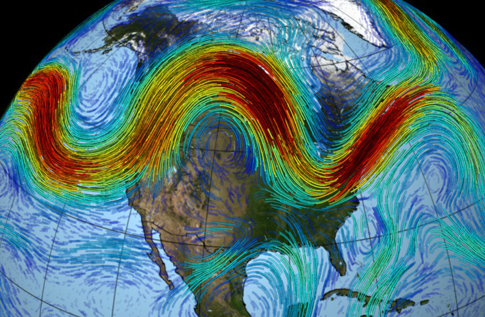
The jet stream—a powerful river of wind high in the atmosphere—shapes the Northern Hemisphere’s weather, including bitter cold snaps. Because it plays a key role in weather extremes, climate scientists are striving to understand its changing dynamics.
Here’s a closer look at what the jet stream is, what’s influencing its wobbly behavior and why it matters.
First things first: What is the jet stream?
The jet stream races from west to east at speeds up to 275 miles an hour, undulating north and south as it goes.
This powerful river of wind transports moisture and moves masses of cold and warm air and storm systems along its path. During the hurricane season, it sometimes helps push Atlantic tropical storms away from the East Coast.
The northern polar jet stream (it has a counterpart in the Southern Hemisphere) is driven partly by the temperature contrast between masses of icy air over the North Pole and warmer air near the equator. Climate change, true to the predictions of the past half century, has led to faster warming in the Arctic than in the temperate zones. So the temperature difference between the two regions has been lessening.
Research suggests that this reduction in the temperature difference is robbing the jet stream of some of its strength, making it wobblier and contributing to more temperature extremes.
What’s the jet stream’s role in extreme weather?
The jet stream is strongest in winter, when it has the greatest effect on weather in more densely populated parts of North America and Eurasia.
When it rolls along in relatively steady waves, normal weather ensues, with spells of cold, snow and intermittent warm-ups.
But when it coils far to the south, bitter cold Arctic air spills southward along with it.

Wriggling like a garden hose, each southward kink in the wind tends to be balanced out by a northward bend somewhere else. That can lead to the western states, even Alaska, being unusually warm and dry while the middle of the country and the eastern states freeze.
How is the jet stream changing?
Research shows that over the past several decades, the jet stream has weakened. There’s also evidence that as it wobbles, it can get stuck out of kilter, which can lead to more persistent weather extremes, including heat waves, cold snaps, droughts and flooding.
Scientists say there is strong evidence that human-caused global warming has altered the strength and path of the powerful winds.
Research into three centuries of European tree ring data by Valerie Trouet of the University of Arizona found evidence of significant changes in the jet stream starting in the 1960s. The recent deviations exceeded normal variations in the past, suggesting a connection to the changing climate. The result: more extreme drought, flooding and heat waves.
What does Arctic warming have to do with it?
Rutgers University climate scientist Jennifer Francis has found “robust relationships” between Arctic warming and a wavier jet stream.
Melting sea ice speeds up the warming of the Arctic because open water absorbs more heat. And that, in turn, leads to even more sea ice melting. In that vicious cycle, Arctic temperatures are rising twice as fast as the global average. And that’s reducing the temperature contrast that’s one of the jet stream’s main engines, Francis said.
More extreme and persistent swings in the jet stream may also be shaping a North American winter weather pattern that’s been common the past few years—a warm and dry West, especially California, and cold waves in the Eastern U.S.
“We think it takes two ingredients to make this pattern so robust. A lot of warm water off the West Coast, and warm conditions and declining sea ice in the western Arctic around Alaska. Both pump a big ridge in the jet stream along the West Coast,” she said. Then, a few thousand miles east, the jet stream dives south, bringing polar air to the East Coast.
Another study last summer by climate scientist Michael Mann and co-authors also found significant evidence for links between the rapidly warming Arctic and a jet stream slowdown.
What questions still remain?
There are other influences on the jet stream’s behavior, and some scientists think that changes in tropical ocean temperatures, or the cyclical recurrence of El Niño, might have a bigger effect on the jet stream than changes in the Arctic.
A team of climate experts who conducted a fast analysis of the late December 2017-early 2018 East Coast cold snap said they didn’t find a link to Arctic temperature or sea ice conditions for that particular event, though the authors noted that their work was a quick analysis and not an in-depth modeling study. They did find that cold spells aren’t as cold as they would be in a climate unaltered by greenhouse gases.
“Because of Arctic amplification, the cold air coming south is not as cold as it used to be,” said Geert Jan van Oldenborgh, a Dutch climate scientist involved in the World Weather Attribution analysis. The decline in cold spells, he said, is “the big signal.”

Bob Berwyn
Reporter, Austria
Bob Berwyn an Austria-based reporter who has covered climate science and international climate policy for more than a decade. Previously, he reported on the environment, endangered species and public lands for several Colorado newspapers, and also worked as editor and assistant editor at community newspapers in the Colorado Rockies.


