


Story and photos By Vince Burns
More than four years after the Thomas Fire, it’s time to assess its lingering effects on our Los Padres National Forest. The giant fire was officially “contained” in January 2018 after wiping out hundreds of homes in Ventura and elsewhere, scorching 281,000 acres, and fouling the county’s air for weeks. We interviewed local experts to understand the current state of our local wilderness and to get recommendations for great hiking this summer. How well has the forest recovered? Are all of our favorite trails and campsites open? In many cases, that answer is yes, and while the fire’s impacts do linger somewhat, this summer is a great time to get out there and explore our local wilderness areas.
The fire was a particular disaster for the city of Ventura because of the large number of homes lost (504). Further south the fallout was even worse, as a deadly flood ravaged Montecito.
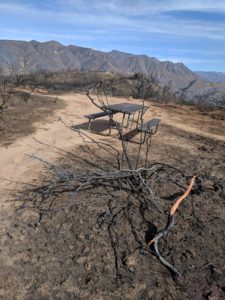
In addition to the devastation in urban and suburban areas, the Los Padres National Forest (LPNF) also suffered. More than half of the fire’s massive footprint was on U.S. Forest Service land, and losses to flora and fauna were staggering. For example, the entire Matilija Wilderness, an isolated tract of chaparral and woods west of Highway 33, was turned overnight into an ashy moonscape.
It was grim, but the dust (and ash) has long since settled, and the Los Padres has healed its wounds, returned to its natural beauty, and opened up for hiking, biking, camping, picnicking and everything else we like to do in the woods.
ARE TRAILS OPEN?
Yes, the Los Padres is open for business after the fire. According to a Forest Service spokesman, “all trails in the Thomas Fire scar are open to the public.”
This good news comes with a relatively large asterisk. An “open” trail to the Forest Service doesn’t necessarily mean a passable (or even recognizable) trail in all cases.
According to LPNF information officer Andrew Madsen, “the Forest Service mitigates tree hazards in and around campgrounds and roads, but hikers should be aware of their surroundings when entering recently burned areas of the forest outside of developed sites.” Translation: Post-fire regrowth of chaparral and trees have in some cases obscured or even hidden once-familiar trails.
Although this is surprising given our seemingly unending drought, 2020 was a fairly normal year in terms of rain, meaning that formerly water- and space-starved plant life exploded that year. This led to overgrown trails, just as housebound hikers headed to the forest to escape the lockdown.
In the case of the heavily burned Matilija Wilderness, for example, this meant that during the worst of COVID, cabin-feverish backpackers and hikers making their way down the Middle Fork of the Matilija Creek were met in 2020 by nearly impenetrable regrowth as they tried to reach the main Matilija Canyon Road trailhead. Some had to turn back. In LPNF parlance, the trail was “open” but for the average hiker or backpacker, the going was extremely tough.
LOCAL GROUPS STEP UP TO OPEN FIRE-DAMAGED TRAILS
To the rescue came the Los Padres Forest Association and other private groups that work closely with the LPNF to keep trails open and viable. Several groups came together after the fire to repair, restore and reopen trails. As a consequence, many local trails have been restored, not by the Forest Service itself but by trail groups using volunteers.
According to Los Padres Forest Association Executive Director Bryan Conant, most Los Padres trails are now in good shape with only a few spots still needing attention. This massive post-fire effort has been a resounding success.
As Conant explains, “the trails have responded well; everyone [the various trail groups] worked together and chipped away. Working to restore our trails together was a great experience to be part of.”
If you’re wondering about the large role of nonprofits in maintaining National Forest trails, the process has been ongoing for years. The LP Forest Association, for example, occasionally does contract trail work for the Forest Service but more often uses grants from nonprofits and, especially, volunteer labor. Trail work in the Matilija area was a volunteer effort, Conant noted.
OJAI VALLEY LAND CONSERVANCY
Although many backcountry hikers in the 805 will end up in the Los Padres, it isn’t the only option in terms of hiking. The Ojai Valley Land Conservancy (OVLC) maintains several trails in our area including Ventura River and Signal Road (Ojai) sections.
The Ventura River area is particularly popular for hikers who do not have the time or inclination to drive deep into the Los Padres on Highway 33 but nevertheless want quick access to the outdoors.
In the aftermath of the fire, hikers at the land conservancy’s Oso trailhead were unable to access the popular Kennedy Ridge Trail because a wooden bridge across the cement canal had been lost in the fire. Happily, that bridge is now rebuilt.
“The worst of the trail damage from the Thomas Fire is now behind us,” reports Brendan Taylor of OVLC.
STRESSED WILDLIFE
That said, Taylor was concerned about a collection of picturesque oak trees in the popular Wills Canyon Trail area of the OVLC’s Ventura River Preserve.
“The fire stressed these trees, they were licked by flame, and damaged,” he explains. “Post-fire we had arborists examine them.”
This concern was borne out when a windstorm in the early spring took down several of the oaks. Although a crew has since cleared the blocked trails, the loss of the oaks is a warning that fires like Thomas can weaken many species, setting trees and other flora up for loss the next time conditions get tough. In normal conditions, damage from fires or dry or windy years is often repairable, but the ongoing drought has piled on further stress. Three of the four “rain years” following the Thomas Fire have been below average.
U.S. FOREST SERVICE REBOOTS
Along with its forests, the division that manages the Los Padres National Forest has been in transition. Ever larger and more frequent fires have increased the percentage of the Forest Service budget that goes toward fire suppression. Partly as a consequence, the days when a hiker might run across a forest service crew maintaining a trail in the backcountry are mostly gone, as private and volunteer groups like the Los Padres Forest Association pick up the slack.
In addition, several key Forest Service staff retired in the years since the Thomas Fire, and recently there were no backcountry rangers for either the Ojai or Santa Barbara ranger districts. Backcountry rangers — with their troves of lore and knowledge of local trail and backcountry conditions — are especially useful to hikers and backpackers. Their disappearance from the local backcountry may impact the Forest Service’s ability to give advice and information on the availability of water, status of trails, and advisability of backcountry plans.
As LPNF Public Affairs officer Andrew Madsen put it earlier this spring, “Los Padres has a number of vacancies on our Recreation staff area. We’re aiming to fill those jobs when funding opportunities arise.”
So (hopefully) reinforcements may be on the way. The Forest Service is also reviewing its management of the Los Padres and other forests in light of increased fire and drought. According to Madsen, “the Forest Service recently embarked on a 10-year wildfire strategy that emphasizes more prescribed burns and fuels reduction work. Funding to address this effort was contained in the Infrastructure Law passed by Congress last year and signed by the President.”
As we are always told, fires in the Los Padres are normal. That said, according to Madsen, only 10% of forest fires are “natural” fires, usually caused by lightning. Even as it adds more controlled burns to its arsenal, the Forest Service is still committed to putting most fires out.
“The Forest Service ‘management philosophy’ is to prevent destructive wildfires with a full suppression,” says Madsen.
It remains to be seen if this tweaked philosophy will spare our local forests from another terrible fire like Thomas.
BEST TRAILS THIS SUMMER
Our drought and the arrival of summer have left us with limited water to enjoy in the backcountry. The bed of the Ventura River is already bone dry in Ojai, but the hills and mountains behind it still have some flowering plants and the hiking can be very good, thanks to the work of Conant’s groups and others. Here’s a curated list of hikes suggested by our local wilderness experts quoted in this story. Be sure to try a few out this summer as you check out how well our mountains have recovered from the Thomas Fire.
Just remember: Bring lots of water, maps, proper clothing, etc. and note that fire season is upon us.
Lion Canyon Trail
A 6 mile out-and-back hike. Trailhead is Middle Lion Campground off of the Rose Valley Road.
Potrero John Trail
5 mile out-and-back with the trailhead near the 32-mile marker on Highway 33. At the end of May there was still some water in the waterfall.
Gene Marshall – Piedra Blanca Trail
This one is for experienced and strong hikers with a full summer day to spend on the 18-mile hike (or via a one- or two-night backpacking trip). It’s point-to-point so you need to shuttle: Start at Reyes Creek Campground and end at the Piedra Blanca Trailhead. If you don’t have time or endurance for the full 18 miles, any portion of the Reyes Peak Trail is great in summer. Because of its forest, there is good shade from the canopy, making for pleasant hiking. The USFS reminds visitors that it is “high and dry,” so bring plenty of water and sunscreen.
Cherry Creek Road Hike
An 11.6 mile out-and-back that starts at Cherry Creek Road on Highway 33.
Wheeler Gorge Nature Trail
Just a little over half a mile, this is great for children learning to appreciate the wilderness as they hike through riparian and chaparral habitats. Enter at the campground.
Luci’s-Foothill-Fox Canyon Loop
On the Valley View Preserve of the OVLC. From the nearest trailhead, it’s about a 3.25-mile hike with some quick elevation gain. Wonderful views of the city of Ojai.
Allan Jacobs Trail
1.4 miles on the Ventura River Preserve. Reach it via the OVLC’s Riverview Trailhead, making for a 5.6-mile loop in all. Featuring a dense riparian habitat on the south side, and then a ridgeline walk through the chaparral with great views of the entire Ojai Valley.
Los Padres National Forest
Ojai Ranger District
661.245.3731
805.448.6487
Los Padres Forest Association
6750 Navigator Drive, #150, Goleta
805.405.8628
Ojai Valley Land Conservancy
370 Baldwin Road, Building A4, Ojai
805.804.9624


